My initial plan for the latest blog article was to feature the change in the landscape as viewed from our local network near Tunnel Woods and Castle Gresley. The 4 cooling towers of Rugeley Power Station finally suffered the fate of the station chimney and were demolished on 6th June. Having followed clear blue skies on the Saturday I took position to record the moment and the change to the landscape from the picnic tables and see the towers disappear in the distance. Sadly the weather and cloud were not so good and I may as well have tried to look for Blackpool Tower at the point of demolition.
 |
| The signal box hints at the area's railway heritage |
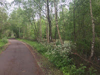
Whilst the changes to the landscape around Rugeley are significant, a more subtle change has recently taken place on NCN63 in Moira and I thought I'd have a closer look.
 |
| Approach from Spring Cottage |
To those familiar with the area I am referring to the stretch between the Spring Cottage Road lodges and up to the Youth Hostel. Part of the Conkers Circuit, this section marks the start of the Ashby Wolds Heritage Trail and is where the route turns away from running alongside the Burton to Leicester Railway Line to follow the Ashby and Nuneaton Joint Railway. Formerly this was a railway junction, hence the signal box and was also the site of a train depot and the Overseal sidings until 1966.
 |
| One of the information boards |
In 1991 work started to change it into a nature reserve with ponds formed between the embankments of the 2 lines. In 1994 it was designated as a Local Nature Reserve. For the last 20 years it has been a feature of part of the Conkers circuit where the route turns back towards Conkers away from the old railway line and has been complimented by the Youth Hostel, campsite and more recently the interpretation hub which features information about the railway history.
The area features ponds and a fair amount of vegetation which make this a pleasant section of the cycle network. Like other sections on the network the vegetation, if not controlled can cause issues both to the immediate environment and also the surface of the path due to build up over several years.
 |
| View of one of the ponds away from NCN |
In the recent winter, a grant funded project took place to improve the conservation value of the area. We have briefly reported changes immediately noticeable from the path itself - mainly the thinning of vegetation. As well as being good for the path, and allowing a better view of the ponds, it also allows more light for wildflowers to grow and promotes growth for bird nesting habitats. This work was led by the ranger team at Leicester County Council and carried out with help from volunteers.
Several changes to conservation methods have taken place including controlled promotion of decaying trees to attract fungi, invertebrates and birds. The ponds themselves have been worked on too, including cleaning. Information boards in the area relay this information in far more detail including the breakdown of the 619 species found in the area. I'm not sure about promoting the search for Fly Agaric - an hallucinogenic fungi found under birch trees!
 |
| NCN63 passing through the reserve |
It was nice to dismount and have a walk off the route around by the ponds and around the old railway buildings which I have been told were used as air raid shelters during World War 2. It will be nice to keep an eye on the reserve when cycling through on a regular basis. It's a lovely part of the NCN.
Changing the subject slightly, but necessarily, the area above falls within North West Leicestershire (NWL) and NWL District Council are currently (until 9th July) running a survey on their Cycling and Walking Strategy. This strategy mainly covers Coalville and Ashby but also covers Measham and the Heart of the National Forest area. This is mainly aimed at residents of NWL but I filled in relevant sections as a visiting cyclist within the area and would recommend those with interest in cycling in National Forest and NWL to fill it in. It takes around 5 minutes.
Documents about the strategy can be found on North West Leicestershire District Council Website and the actual survey can be found be clicking
here.


